Meteorologists indeed keep a keen eye on the polar vortex due to its crucial influence on weather patterns throughout the Northern Hemisphere. The polar vortex, a large area of low pressure and cold air surrounding both of Earth’s poles, acts as a key player in shaping atmospheric circulation.
Alterations in the intensity and location of the polar vortex can result in notable weather irregularities, such as severe cold spells, intensified winter storms, and alterations in the jet stream’s trajectory. These variations have far-reaching implications for weather forecasting, as well as for climate research endeavors.
By comprehending and foreseeing these fluctuations, meteorologists can enhance their ability to predict and prepare for weather events, ultimately aiding in the mitigation of potential risks associated with extreme weather phenomena. Furthermore, a deeper understanding of the polar vortex assists scientists in unraveling the complexities of our planet’s climate system, contributing to advancements in climate science and our overall comprehension of Earth’s atmospheric dynamics.
Source: https://scijinks.gov/polar-vortex/
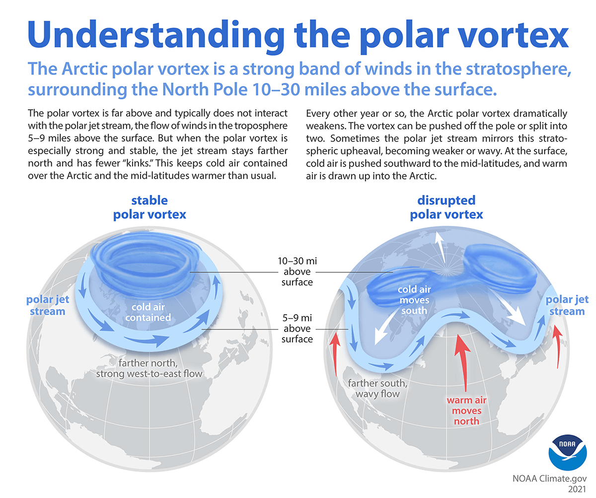
The text also discusses the connection between the polar vortex and the Arctic Oscillation (AO), emphasizing their influence on winter weather in the United States and Europe. It explains that the polar vortex, a permanent atmospheric circulation feature, contains the coldest air at the poles. The polar jet stream, marking the outer edge of the vortex, is influenced by temperature, wind, and air pressure patterns that extend from high altitudes to the surface, particularly in winter.
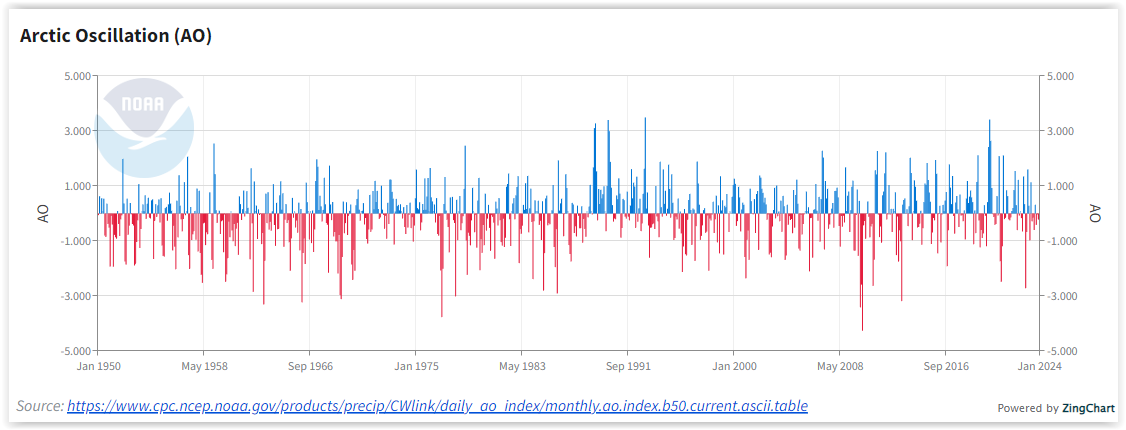
The Arctic Oscillation describes coordinated shifts in the polar vortex’s characteristics, affecting air pressure, temperature, and the jet stream’s location and strength. A strong polar vortex, with higher pressure over the Arctic, results in milder conditions in mid-latitudes, while a weak vortex, characterized by lower Arctic pressure, allows frigid air to move southward. The AO Index tracks these variations.
Source: https://www.ncei.noaa.gov/access/monitoring/ao/
The text notes a recent cold outbreak, attributing it to a weakened polar vortex near North America and eastern Siberia. Unlike a complete vortex breakdown, parts of the Arctic Circle experienced warmer temperatures. It contrasts this event with the classic example of a strong negative AO phase in 2009-2010, causing widespread cold outbreaks in North America, Siberia, and Europe.
While the AO has not shown a strongly negative phase recently, there is a trend of more frequent negative phases since the mid-1990s, and researchers are exploring factors like natural variability, sea ice loss, and snow cover influence. The Climate Prediction Center forecasts the AO and North Atlantic Oscillation (NAO) up to two weeks ahead, indicating potential cold snaps in the central and eastern United States. However, model predictions for the Arctic Oscillation’s phase show a mixed outlook, with low confidence in the forecast for the end of January. The text also mentions the interrelation between AO and NAO during the winter, citing a deviation in alignment during the cold outbreak in early 2014.
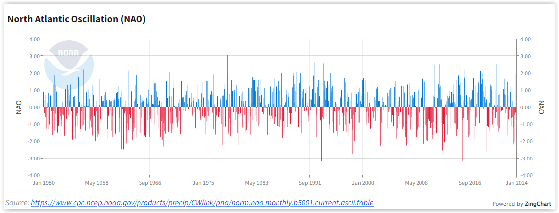
The North Atlantic Oscillation (NAO) and Arctic Oscillation (AO) are climate indices that represent patterns of atmospheric pressure variations in the Northern Hemisphere. These indices are primarily associated with large-scale weather patterns and climate variability but are not directly related to ships.
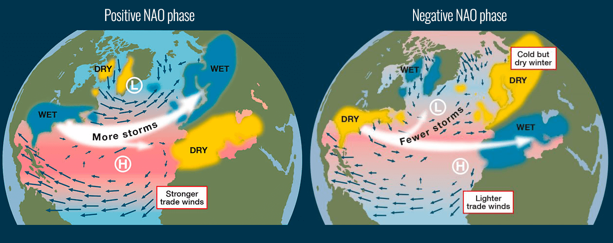
The NAO is characterized by the difference in atmospheric pressure between the subtropical high-pressure system near the Azores and the subpolar low-pressure system near Iceland. It has two phases: positive and negative. A positive NAO is associated with stronger westerly winds and milder, wetter conditions over northern Europe, while a negative NAO is linked to weaker westerly winds and colder, drier conditions.
The AO represents the state of atmospheric circulation over the Arctic region. It is measured by the difference in atmospheric pressure between the Arctic and the middle latitudes. The positive phase of the AO is associated with a strong polar vortex and milder conditions in the mid-latitudes, while the negative phase is linked to a weaker polar vortex and increased chances of cold outbreaks in the mid-latitudes.
The relationship between these indices and ships is indirect. The NAO and AO influence the prevailing weather patterns, which can impact shipping routes, sea ice conditions, and overall maritime weather in the North Atlantic region. For example, during a negative NAO or AO phase, colder conditions may prevail, potentially affecting shipping operations. However, it’s essential to note that while these indices can provide insights into long-term climate trends, short-term weather conditions are influenced by various factors, and their direct impact on specific ship operations can vary.
Source: https://www.severe-weather.eu/
Meteorologist: Nikos Koulakis