
OCEANIC-ATMOSPHERIC OSCILLATIONS
EL NINO SOUTHERN OSCILLATION (ENSO)
El Nino and La Nina are the opposite phases of what is called El Nino-Southern Oscillation cycle. El Nino is the warm phase of ENSO and La Nina the cold phase of ENSO. ENSO describes the fluctuations in temperature between the ocean and atmosphere in the east-central equatorial Pacific. ENSO usually occurs every 2-7 years and can have a huge impact, not only on ocean processes but also on global weather patterns. When El Nino and La Nina take place, typically last 9-12 months but El Nino appears more frequently than La Nina.
During normal conditions or ENSO-neutral year, a low pressure system lies over northern Australia and Indonesia and high pressure on the other side of the Pacific over Peru. Simultaneously, the trade winds blow steadily from east to west pushing warm surface waters from east to west Pacific causing cold and nutrient-rich bottom water moving up off the coast of S. America.
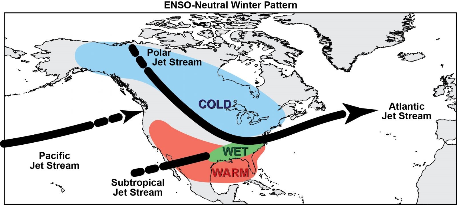 Typical winter impacts associated with ENSO neutral events. Colder probabilities are favored across north-central and northeast portions of the US, due to a polar jet stream shifted further south. Meanwhile, warmer probabilities are favored across the southern US, with above normal precipitation favored across portions of the southeast US. Image courtesy of Ray Wolf, National Weather Serivce.
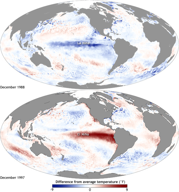
El Nino means ‘little boy’ in Spanish given by Peruvian fishermen when more than 100 years ago noticed changes in anchovy populations around Christmas time due to extraordinary warm surface waters in the eastern tropical Pacific ocean.
Normally the Peru (Humboldt) Current brings cold water from the Southern Ocean northwards along the west coast of South America. Along the coast of Peru this water is enhanced by up-welling, due to trade winds, which positively affects the sea life of the area. Under the influence of the equatorial trade winds, this cold water moves west along the equator where it is slowly heated by the sun. Thus sea surface temperatures(SSTs) in western Pacific are generally warmer by 8-10oC than those in eastern Pacific.
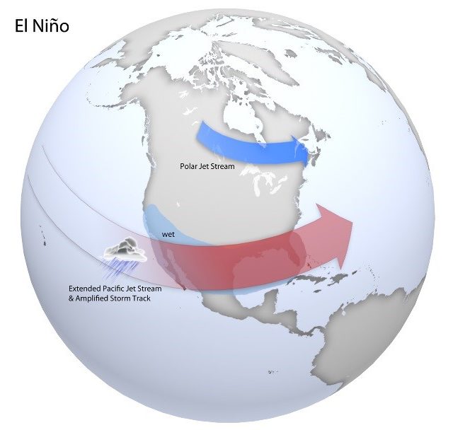
In an El Nino year, the low pressure system over west Pacific weakens and so diminishes or reverses the trade winds to transport warm surface water towards South America. This reduces the upwelling near the coast which further diminishes high pressure over Peru and even further the trade winds.
During El Nino years the water in eastern Pacific becomes as warm as the western Pacific.
Its climate impacts show up mostly in wintertime over N. America. The warmer ocean fuels an intensification and southward shift of the jet stream. This brings flooding to the southern United States and warmer, drier conditions over parts of the NW Pacific, northern US and Canada.
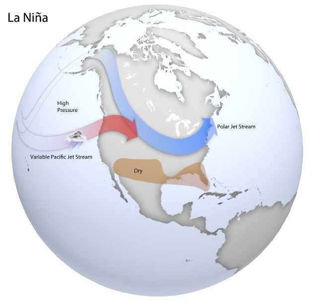
On the other hand, La Nina means ‘little girl’ in Spanish and it is the reverse of El Nino. This time, the eastern tropical Pacific waters are colder than normal. During La Nina event, the trade winds become stronger than normal, blowing more warm water to the west, leaving more room in the area of eastern pacific for cold upwelling. These unusually cold conditions in the tropical Pacific displace the jet stream northwards. In places where it is exceptionally cool and wet during El Nino, it is generally hot and dry during La Nina. La Nina can lead to draught in the southern US and cooler temperatures, heavy rain and flooding in the Pacific NW. La Nina conditions are also associated with an increasing number of tropical storms in the Atlantic Ocean, whereas El Nino brings more severe tropical storms to the Pacific.
El Nino and La Nina together are part of a cycle that influences extreme weather and can impact food production, water supply and even human health not just in the US but in many parts of the globe. The cycle of ENSO is not a regular oscillation like the season change but it is much more erratic in strength, timing and pattern. However, it generally occurs every 2-7 years as mentioned before.
NORTH ATLANTIC OSCILLATION (NAO)
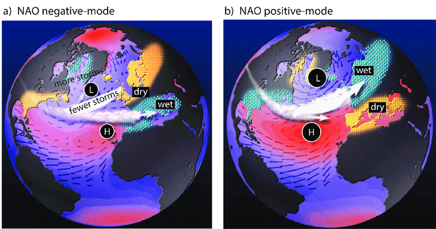
The North Atlantic Oscillation (NAO) is one of the most prominent teleconnection patterns affecting the weather systems in the northern hemisphere. The NAO index is based on the surface sea-level pressure difference between Azores high and Icelandic low. It shows considerable interseasonal and interannual variability and prolonged periods of several months of both positive and negative phases of the pattern are common. The positive phase of NAO reflects below-normal heights and pressure across the high latitudes of the N. Atlantic and above normal heights and pressure over the central N Atlantic, eastern US and W Europe. The negative phase reflects the opposite pattern over these regions. Both phases of the NAO are associated with changes in location and intensity of the North Atlantic jet stream and consequently the storm track. The periodic change of NAO affects the strength of the prevailing winds in the N hemisphere, the westerlies, and therefore the weather patterns. These wind variations affect in turn the strength and direction of ocean surface currents in N Atlantic. Positive NAO indicates high pressure over Azores and an intense low over Iceland resulting in stronger winds. Strong positive NAO indicates above average temperatures in eastern US and across N Europe and below average temperatures in Greenland and often across southern Europe and Middle East. Additionally, there is above average precipitation over northern Europe and Scandinavia in winter and below average precipitation over southern and central Europe. Opposite temperature and precipitation patterns are observed during strong negative NAO. During particular prolonged periods dominated by one particular NAO phase, anomalous height and temperature patterns can also be extended well into central Russia and north-central Siberia.
ARCTIC OSCILLATION (AO)
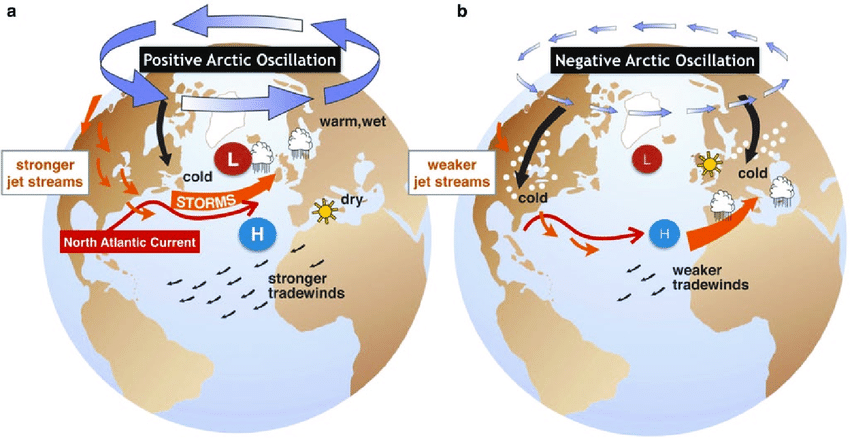
The Arctic circulation is a climate pattern characterized by winds spinning counterclockwise around the Arctic at about 55oN latitude. The intensity of atmospheric pressure difference between the North Pole and middle northern latitudes create the positive and the negative phase of the AO. When AO is positive (warm), strong winds circulating around the North Pole confine colder air across polar regions. This results in mild winter weather being experienced by much of the US and N Europe but drought conditions being established over the Mediterranean. This belt of winds becomes weaker and more distorted when AO is in its negative phase, meaning higher than normal atmospheric pressure lies over the Arctic region and lower than normal pressure over the central Atlantic Ocean. This situation allows an easier southward penetration of colder, arctic airmasses along with increased storminess into the mid-latitudes due to the weaker westerlies derived from the pressure difference. During the negative (cool) phase, much of the US, N Europe and Asia experience cold and stormy winters. More storms also develop over the Mediterranean region.
The AO and NAO are collectively referred to as the Northern Annular Mode (NAM).
ANTARCTIC OSCILLATION (AAO)
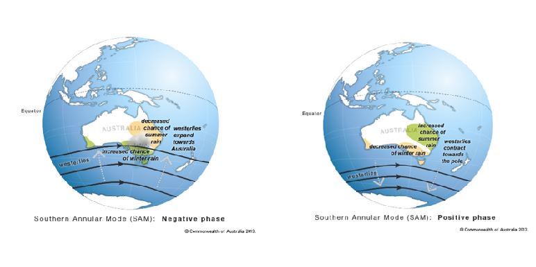
The Antarctic Oscillation (AAO) is a measure of the pressure gradient between the polar and subpolar regions of the Southern Hemisphere. It describes the north–south movement of the westerly wind belt that circles Antarctica, dominating the middle to higher latitudes of the southern hemisphere. AAO is also known as Southern Annular Mode (SAM) and it is the opposite pattern of NAM. The changing position of the westerly wind belt affects the position of cold fronts and storm systems in mid latitudes which in turn affects the rainfall variability in southern Australia. When AAO is in its positive phase, the belt of westerly winds contracts towards Antarctica. This leads to weaker westerlies than normal and higher pressures over southern Australia, a combination of which restricts the penetration of cold fronts inland. During autumn and winter, positive values of AAO mean cold fronts are further south and thus southern Australia misses lots of the rain. However in spring and summer, a strong positive AAO means that southern Australia is affected by the northern half of high pressure systems and therefore there are more easterlies bringing moist air from Tasman Sea. This moisture can fall as rain when winds hit the coast. When AAO is in its negative phase, the belt of strong westerly winds expands towards the equator. This shift in the westerlies result in more (or stronger) storms as low pressure systems cross the southern Australia.
MADDEN-JULIAN OSCILLATION (MJO)
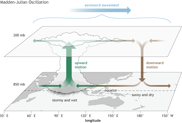
The Madden-Julian-Oscillation (MJO) is an eastward moving disturbance of clouds, rainfall, winds and pressure that crosses the planet in the tropics and returns to its initial point in 30-60 days on average. Unlike ENSO which is stationary, this moving disturbance is associated with persistent weather situations which last several seasons or longer over the Pacific. There can be multiple MJO events within a season and thus MJO is described as intraseasonal tropical climate variability (can vary on a week to week basis). It was named after Roland Madden and Paul Julian who first described it when they noticed regular oscillations in winds between Singapore and Canton Island in the west central equatorial Pacific. It is the main oscillation behind weather variations in the tropics and subtropics.
How does the MJO work?
An area of enhanced tropical rainfall is first apparent over the western Indian Ocean. This area spreads eastwards into the warm waters of the tropical Pacific. This pattern of tropical rainfall tends to lose intensity as it crosses the cooler waters of the eastern Pacific before reappears at some point over the Indian Ocean again. A wet phase of enhanced convection (rainfall) is followed by a dry phase, where thunderstorm activity is suppressed (no rainfall). Each cycle lasts circa 30-60 days as mentioned earlier.
MJO influences the global weather in a number of ways:
– It affects the intensity and break periods of the Asian and Australian monsoons. The enhanced rainfall phase of MJO can bring the onset of the monsoon season around the globe whereas the suppressed rainfall phase can delay the onset of the monsoon season.
– MJO also interacts with the southern oscillation, contributing to the speed of development and intensity of an El Nino or La Nina event. MJO appears to be more active during neutral and weak ENSO years.
– MJO creates favourable conditions for tropical cyclone activity and this makes MJO important to monitor during the Atlantic hurricane season.
– There is also evidence to suggest that MJO influences the onset of a sudden stratospheric warming (SSW) event.
Author: Triantafyllia Sideri / Operational Meteorologist